
 Continue with onX Maps
 Sign in with Facebook


The Fortress Rock Climbing
Use onX Backcountry to explore the terrain in 3D, view recent satellite imagery, and more. Now available in onX Backcountry Mobile apps! For more information see this post.
| Elevation: | 8,500 ft | 2,591 m |
| GPS: |
32.4318, -110.7985 Google Map · Climbing Area Map |
|
| Page Views: | 144,111 total · 529/month | |
| Shared By: | Hendrixson on Sep 9, 2002 | |
| Admins: | adrian montaño, Greg Opland, Brian Boyd, JJ Schlick, Kemper Brightman, Luke Bertelsen |
 Access Issue: Potentially unavailable to climbing February through July if raptors are breeding here.
Details
Access Issue: Potentially unavailable to climbing February through July if raptors are breeding here.
Details
This area is historically used by nesting falcons, hawks, owls or other raptors. Breeding season varies but is roughly February through July. Nesting raptors are protected by law.
If you aren't sure if raptors are breeding here, then listen and watch for defensive behavior such as screeching or diving (links to info). If raptors are breeding in this area please climb somewhere else and let other climbers know.
Pressures on wildlife can be immense and are multiplied by effects of climate change and pollutants. Choosing to climb away from nest sites reduces unnecessary stresses to the birds. Give these animals a chance to thrive.
More info here: theclimbershome.org/breedin…
Description

The Fortress is one of the best and most varied crags on Mount Lemmon. The Southeast Face boasts amazing sport and traditional multi-pitch routes. The Orifice Wall, which is a sharp contrast to the face routes, boasts some of the hardest and steepest routes in the region. The Fortress along with the other summit crags should not be missed.
Be sure to observe the season closure from March 15 to June 30 peregrine falcon nesting.
Be sure to observe the season closure from March 15 to June 30 peregrine falcon nesting.
Getting There
Drive up Mount Lemmon Highway (Catalina Highway) for approximately 22.5 miles. Turn right on Ski Run Road, immediately prior to entering the town of Summerhaven, and follow this road approximately 4.5 miles. While on Ski Run Road continue through the Ski Valley parking lot where the road narrows and winds up the last section of the mountain. Upon reaching the closed gate of the Mount Lemmon SkyCenter Observatory turn left into a parking lot. A restroom and free camping can be found here. There is no running water.
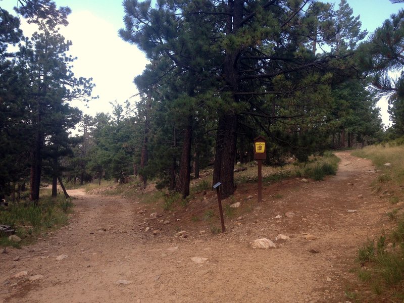
Hike around fenced-in generators on a narrow trail used by climbers and hikers alike (Photo 1 below). In a couple minutes, at the SkyCenter Observatory sign a fork will be encountered (Photo 2 below). The Fortress can be reached by following either the access road (left) or Meadow Trail (right). The latter is more scenic and less rocky but slightly longer.
If you take the access road, follow the rocky road downhill past both a trail turnoff and a lookout point. The view will open and a metal shed will appear. Near the shed is a spring on the left (downhill) side of the trail. I believe the spring is safe to drink and always running. Continue past the shed and the turn off for Rappel Rock. Hike past the where the Meadow Trail rejoins the access road.
Turn left onto a climber's trail immediately after the green electrical box on your right (Photo 3 below). Hike past the west face of The Murray Wall to the Fortress. The Southeast Face is on your left; the Northwest Face is on your right.
Expect the drive to take 45-60 minutes and the hike to take 20-30 minutes.
![]()
![]()
![]()
Hike around fenced-in generators on a narrow trail used by climbers and hikers alike (Photo 1 below). In a couple minutes, at the SkyCenter Observatory sign a fork will be encountered (Photo 2 below). The Fortress can be reached by following either the access road (left) or Meadow Trail (right). The latter is more scenic and less rocky but slightly longer.
If you take the access road, follow the rocky road downhill past both a trail turnoff and a lookout point. The view will open and a metal shed will appear. Near the shed is a spring on the left (downhill) side of the trail. I believe the spring is safe to drink and always running. Continue past the shed and the turn off for Rappel Rock. Hike past the where the Meadow Trail rejoins the access road.
Turn left onto a climber's trail immediately after the green electrical box on your right (Photo 3 below). Hike past the west face of The Murray Wall to the Fortress. The Southeast Face is on your left; the Northwest Face is on your right.
Expect the drive to take 45-60 minutes and the hike to take 20-30 minutes.


Classic Climbing Routes at The Fortress
Mountain Project's determination of the classic, most popular, highest rated climbing routes in this area.


Weather Averages
|
High
|
Low
|
|
Precip
|
Days w Precip
|
Prime Climbing Season
| J | F | M | A | M | J | J | A | S | O | N | D |
| J | F | M | A | M | J | J | A | S | O | N | D |
Photos


All Photos Within The Fortress
Most Popular · Newest · RandomMore About The Fortress
Printer-FriendlyWhat's New
Guidebooks (9)


27 Comments