
 Continue with onX Maps
 Sign in with Facebook


The Maiden
Rock Climbing

Routes in The Maiden

|
Belladonna T 5.11b 6c 23 VIII- 23 E3 5c R |
|
|
Cunning Stunt T 5.10d 6b+ 21 VII+ 21 E3 5b R |

|
Direct North Face T 5.9 5c 17 VI 17 HVS 5a R |
|
|
Dream Street Rose T 5.11b/c 6c+ 23 VIII- 24 E4 6a |
|
|
East Ridge T 5.10c 6b 20 VII 20 E2 5b |

|
Eye Of the Storm T 5.9+ 5c 17 VI 17 E1 5a X |
|
|
Gates of Delirium, The S 5.11c 6c+ 24 VIII- 24 E4 6a |
|
|
Gates of Galas T,TR 5.10d 6b+ 21 VII+ 21 E3 5b X |
|
|
Hasta La Hueco S 5.13b 8a 29 IX+ 30 E7 6c |
|
|
Heart of the Sunrise S 5.11- 6c 22 VIII- 22 E3 5c |
|
|
Kor-Dalke Route T 5.12a 7a+ 25 VIII+ 25 E5 6a R |
|
|
Maiden Voyage S 5.12c 7b+ 27 IX- 27 E6 6b |
|
|
North Face T 5.6 4c 14 V 12 S 4b R |
|
|
North Side of the Sky S 5.12b 7b 26 VIII+ 26 E5 6b |
|
|
Queen-line T 5.13c/d 8b 31 X 31 E8 7a |
|
|
South Crack T 5.11b 6c 23 VIII- 23 E3 5c |
|
|
South Face T 5.8 5b 16 VI- 15 HVS 4c R |
|
|
Southern Seas, The TR 5.11b 6c 23 VIII- 23 E3 5c |
|
|
West Overhang T 5.11b/c 6c+ 23 VIII- 24 E4 6a |
| Elevation: | 7,315 ft | 2,230 m |
| GPS: |
39.95002, -105.28719 Google Map · Climbing Area Map |
|
| Page Views: | 144,364 total · 493/month | |
| Shared By: | Mike Sofranko on Dec 31, 2000 · Updates | |
| Admins: | Leo Paik, John McNamee, Frances Fierst, Monty, Monomaniac, Tyler KC |
 Access Issue: 2024 Crag Closures & Temporary Trail and Raptor Closures
Details
Access Issue: 2024 Crag Closures & Temporary Trail and Raptor Closures
Details
See: bouldercolorado.gov/service….
Click here for the trail closures. Some are M-F, some are 24/7. These impact the Bear Canyon/Fern Canyon regions primarily:
flatironsclimbing.org/tempo…
Click here bouldercolorado.gov/service… for the latest in raptor closures.
Description

Viewed from the east, this crag is a nearly invisible blade of rock tucked in between other seemingly more substantial flatirons. However, while driving to Eldorado Canyon, the careful eye will discern the true nature of the Maiden. From the south, the Maiden is shaped like a dolphin leaping up the wave of the foothills. Climbers will immediately notice the imposing overhang on its west side as well as the vertical nature of its east ridge. No other summit in the Boulder area appears more improbable.
Up close, the effect is amplified rather than diminished. The east ridge terminates in the trees with a disturbingly narrow girth. The north and south faces are sheer, and the low angle west ridge terminates at a narrow vertical west face that leads to the amazing west overhang and the summit. Like Wyoming's Devil's Tower and Utah's Ancient Art, the Maiden appears to be of other-worldly construction.
One of the highlights of any ascent of the Maiden is actually the descent. The rappel off the summit and over the West overhang is simply unbelievable. After completing this rappel for the first time, I couldn't believe that kind of excitement was both free and legal.
The Maiden sports routes of all levels of difficulty. The easiest route is the convoluted North Face at 5.6. Next up is the South Face at 5.8. The narrow East Ridge is climbed with a couple pitches of 5.10, and the fearsome West Overhang can be breached with a pitch of 5.11. Other routes of note are South Crack (5.11) and Cunning Stunt (5.11-).
Getting There
The Maiden is a bit of a hike from the trailhead which tends to keep the crowds to a minimum. Begin at the southern end of the Mesa Trail, and hike until directly below the Maiden, which will be hidden in the trees. When hiking the Mesa Trail, looking for the left turn onto the Shadow Canyon Trail, take the *second* intersection of the Shadow Canyon trail with the Mesa trail, NOT the first. The trail is a loop, and the Maiden is above the section where Shadow Canyon intersects Mesa the second time. Per D Hammond: accessing this from South Mesa Trailhead, this will be the third intersection with Mesa and a Shadow Canyon derivative (the first is with Shadow Canyon South Trail; the second is with Shadow Canyon South Spur; the *third* and the one you want is with Shadow Canyon North Trail. The Maiden is above the section where Shadow Canyon North intersects Mesa. The Maiden is intermittently visible through the trees to the west as one approaches the correct intersection. It is not visible at the first intersection.
The Shadow Canyon trail connects to the Mesa Trail at an old water trough. The water trough is on the east side of the trail at a bend in the trail and is obvious. Turn left on the Shadow Canyon trail and walk up this for a couple minutes (don't go too far). Begin looking to the right through the trees. When hiking up the Shadow Canyon trail briefly, there is a cairn at the point where one should begin thinking about leaving the trail to the right. This cairn will get one to the south face of the Maiden. Interestingly, it won't get one there via the easiest route. A better trail exists just a bit further up Shadow Canyon than the first cairn. When talus is visible, follow a faint path through the woods (watch for poison ivy) to the talus. You should be near an old, shallow quarry pit. A wall will be visible up the unstable talus slope, which marks an old stretch of access road for the quarry. The talus is bordered on the right by a strip of trees. There is a faint path up through the strip of trees - follow that, or scramble directly to the road. The road goes through the strip of trees - at this point head up a path that follows the strip of trees. Eventually, this steep path will deposit you at the base of the East Ridge. Allow a couple hours for the approach and plan on maybe getting lost the first time.
Or per Andy Westmeyer: from South Mesa Trail, follow until you hit the North Shadow Canyon Trail (not the South). Make a left at the North Shadow Canyon Trail, and an obvious cairn will be on the right as is a climber's trail that you want. Follow a faint path through the woods (watch for poison ivy) to an old shallow quarry pit. You should be near an old, shallow quarry pit. There is a faint path up through the strip of trees - follow that, or scramble directly to the road. The road goes through the strip of trees - at this point head up a path that follows the strip of trees. Eventually, this steep path will deposit you at the base of the East Ridge. Allow a couple hours for the approach, and plan on maybe getting lost the first time.
To descend from the summit, make a double rope rappel (or likely a 70m rope) from bolts with chains (previously slings) down over the West Overhang . This will deposit you at the Crow's Nest. From there, either reverse the first half of the North Face route, or do another double rope rappel from the bolt down the south face.
Google satellite map: https://goo.gl/maps/k2xhVgxGUatL1jBEA.
Map 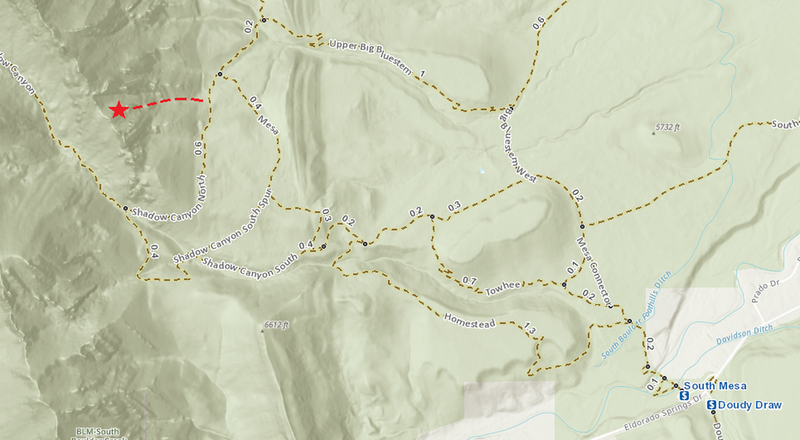
Classic Climbing Routes at The Maiden
Weather Averages
|
High
|
Low
|
|
Precip
|
Days w Precip
|
| J | F | M | A | M | J | J | A | S | O | N | D |
| J | F | M | A | M | J | J | A | S | O | N | D |
Photos


All Photos Within The Maiden
Most Popular · Newest · RandomMore About The Maiden
Printer-FriendlyWhat's New
Fixed Hardware Report (13)
Guidebooks (14)


23 Comments